25 August 2016. Researchers from South African and European universities, and other organisations, are trying to create the first savannah-water-use-and-stress-maps, to help smallholder farmers face the lack of precipitation and plan irrigation.
Field and Earth observation data, obtained from the European Space Agency’s (ESA) Sentinel satellites, will allow the researchers, led by Timothy Dube, at the University of KwaZulu-Natal in South Africa, and Ana Andreu, at UNU-FLORES in Germany, to determine the health and vulnerability of the ecosystem. They recently collected their first field data in arguably one of Africa’s best-known patches of savannah – the Kruger National Park.
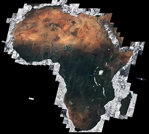
In this context, the ESA has just released the African mosaic, which offers a cloud-free view of the continent through 7,000 images captured by the Sentinel-2A satellite. It provides information that can be used to map changes in land cover and improve agricultural practices.
Source: PAEPARD FEED
by secretary
by secretary
by secretary
by secretary
by secretary
by secretary
by secretary
by secretary
by secretary
by secretary
by secretary
by secretary
by secretary
by secretary
by secretary
by secretary
by secretary
by secretary
by secretary
by secretary
by secretary
by secretary
by secretary
by secretary
by secretary
by secretary
by secretary
by secretary
by secretary
by secretary
by secretary
by secretary
by secretary
by secretary
by secretary
by secretary
by secretary
by secretary
by secretary
by secretary
by secretary
by secretary
by secretary
by secretary
by secretary
by secretary
by secretary
by secretary
by secretary
by secretary
by secretary
by secretary
by secretary
by secretary
by secretary
by secretary
by secretary
by secretary
by secretary
by secretary
by secretary
by secretary
by secretary
by secretary
by secretary
by secretary
by secretary
by secretary
by secretary
by secretary
by secretary
by secretary
by secretary
by secretary
by secretary
by secretary
by secretary
by secretary
by secretary
by secretary
by secretary
by secretary
by secretary
by secretary
by secretary
by secretary
by secretary
by secretary
by secretary
by secretary
by secretary
by secretary
by secretary
by secretary
by secretary
by secretary
by secretary
by secretary
by secretary
by secretary
by secretary
by secretary
by secretary
by secretary
by secretary
by secretary
by secretary
by secretary
by secretary
by secretary
by secretary
by secretary
by secretary
by secretary
by secretary
by secretary
by secretary
by secretary
by secretary
by secretary
by secretary
by secretary
by secretary
by secretary
by secretary
by secretary
by secretary
by secretary
by secretary
by secretary
by secretary
by secretary
by secretary
by secretary
by secretary
by secretary
by secretary
by secretary
by secretary
by secretary
by secretary
by secretary
by secretary
by secretary
by secretary
by secretary
by secretary
by secretary
by secretary
by secretary
by secretary
by secretary
by secretary
by secretary
by secretary
by secretary
by secretary
by secretary
by secretary
by secretary
by secretary
by secretary
by secretary
by secretary
by secretary
by secretary
by secretary
by secretary
by secretary
by secretary
by secretary
by secretary
by secretary
by secretary
by secretary
by secretary
by secretary
by secretary
by secretary
by secretary
by secretary
by secretary
by secretary
by secretary
by secretary
by secretary
by secretary
by secretary
by secretary
by secretary
by secretary
by secretary
by secretary
by secretary
by secretary
by secretary
by secretary
by secretary
by secretary
by secretary
by secretary
by secretary
by secretary
by secretary
by secretary
by secretary
by secretary
by secretary
by secretary
by secretary
by secretary
by secretary
by secretary
by secretary
by secretary
by secretary
by secretary
by secretary
by secretary
by secretary
by secretary
by secretary
by secretary
by secretary
by secretary
by secretary
by secretary
by secretary
by secretary
by secretary
by secretary
by secretary
by secretary
by secretary
by secretary
by secretary
by secretary
by secretary
by secretary
by secretary
by secretary
by secretary
by secretary
by secretary
by secretary
by secretary
by secretary
by secretary
by secretary
by secretary
by secretary
by secretary
by secretary
by secretary
by secretary
by secretary
by secretary
by secretary
by secretary
by secretary
by secretary
by secretary
by secretary
by secretary
by secretary
by secretary
by secretary
by secretary
by secretary
by secretary
by secretary
by secretary
by secretary
by secretary
by secretary
by secretary
by secretary
by secretary
by secretary
by secretary
by secretary
by secretary
by secretary
by secretary
by secretary
by secretary
by secretary
by secretary
by secretary
by secretary
by secretary
by secretary
by secretary
by secretary
by secretary
by secretary
by secretary
by secretary
by secretary
by secretary
by secretary
by secretary
by secretary
by secretary
by secretary
by secretary
by secretary
by secretary
by secretary
by secretary
by secretary
by secretary
by secretary
by secretary
by secretary
by secretary
by secretary
by secretary
by secretary
by secretary
by secretary
by secretary
by secretary
by secretary
by secretary
by secretary
by secretary
by secretary
by secretary
by secretary
by secretary
by secretary
by secretary
by secretary
by secretary
by secretary
by secretary
by secretary
by secretary
by secretary
by secretary
by secretary
by secretary
by secretary
by secretary
by secretary
by secretary
by secretary
by secretary
by secretary
by secretary
by secretary
by secretary
by secretary
by secretary
by secretary
by secretary
by secretary
by secretary
by secretary
by secretary
by secretary
by secretary
by secretary
by secretary
by secretary
by secretary
by secretary
by secretary
by secretary
by secretary
by secretary
by secretary
by secretary
by secretary
by secretary
by secretary
by secretary
by secretary
by secretary
by secretary
by secretary
by secretary
by secretary
by secretary
by secretary
by secretary
by secretary
by secretary
by secretary
by secretary
by secretary
by secretary
by secretary
by secretary
by secretary
by secretary
by secretary
by secretary
by secretary
by secretary
by secretary
by secretary
by secretary
by secretary
by secretary
by secretary
by secretary
by secretary
by secretary
by secretary
by secretary
by secretary
by secretary
by secretary
by secretary
by secretary
by secretary
by secretary
by secretary
by secretary
by secretary
by secretary
by secretary
by secretary
by secretary
by secretary
by secretary
by secretary
by secretary
by secretary
by secretary
by secretary
by secretary
by secretary
by secretary
by secretary
by secretary
by secretary
by secretary
by secretary
by secretary
by secretary
by secretary
by secretary
by secretary
by secretary
by secretary
by secretary
by secretary
by secretary
by secretary
by secretary
by secretary
by secretary
by secretary
by secretary
by secretary
by secretary
by secretary
by secretary
by secretary
by secretary
by secretary
by secretary
by secretary
by secretary
by secretary
by secretary
by secretary
by secretary
by secretary
by secretary
by secretary
by secretary
by secretary
by secretary
by secretary
by secretary
by secretary
by secretary
by secretary
by secretary
by secretary
by secretary
by secretary
by secretary
by secretary
by secretary
by secretary
by secretary
by secretary
by secretary
by secretary
by secretary
by secretary
by secretary
by secretary
by secretary
by secretary
by secretary
by secretary
by secretary
by secretary
by secretary
by secretary
by secretary
by secretary
by secretary
by secretary
by secretary
by secretary
by secretary
by secretary
by secretary
by secretary
by secretary
by secretary
by secretary
by secretary
by secretary
by secretary
by secretary
by secretary
by secretary
by secretary
by secretary
by secretary
by secretary
by secretary
by secretary
by secretary
by secretary
by secretary
by secretary
by secretary
by secretary
by secretary
by secretary
by secretary
by secretary
by secretary
by secretary
by secretary
by secretary
by secretary
by secretary
by secretary
by secretary
by secretary
by secretary
by secretary
by secretary
by secretary
by secretary
by secretary
by secretary
by secretary
by secretary
by secretary
by secretary
by secretary
by secretary
by secretary
by secretary
by secretary
by secretary
by secretary
by secretary
by secretary
by secretary
by secretary
by secretary
by secretary
by secretary
by secretary
by secretary
by secretary
by secretary
by secretary
by secretary
by secretary
by secretary
by secretary
by secretary
by secretary
by secretary
by secretary
by secretary
by secretary
by secretary
by secretary
by secretary
by secretary
by secretary
by secretary
by secretary
by secretary
by secretary
by secretary
by secretary
by secretary
by secretary
by secretary
by secretary
by secretary
by secretary
by secretary
by secretary
by secretary
by secretary
by secretary
by secretary
by secretary
by secretary
by secretary
by secretary
by secretary
by secretary
by secretary
by secretary
by secretary
by secretary
by secretary
by secretary
by secretary
by secretary
by secretary
by secretary
by secretary
by secretary
by secretary
by secretary
by secretary
by secretary
by secretary
by secretary
by secretary
by secretary
by secretary
by secretary
by secretary
by secretary
by secretary
by secretary
by secretary
by secretary
by secretary
by secretary
by secretary
by secretary
by secretary
by secretary
by secretary
by secretary
by secretary
by secretary
by secretary
by secretary
by secretary
by secretary
by secretary
by secretary
by secretary
by secretary
by secretary
by secretary
by secretary
by secretary
by secretary
by secretary
by secretary
by secretary
by secretary
by secretary
by secretary
by secretary
by secretary
by secretary
by secretary
by admin
by admin
by admin
by admin
by admin
by admin
by admin
by admin
by admin