 |
|
View/Open
|
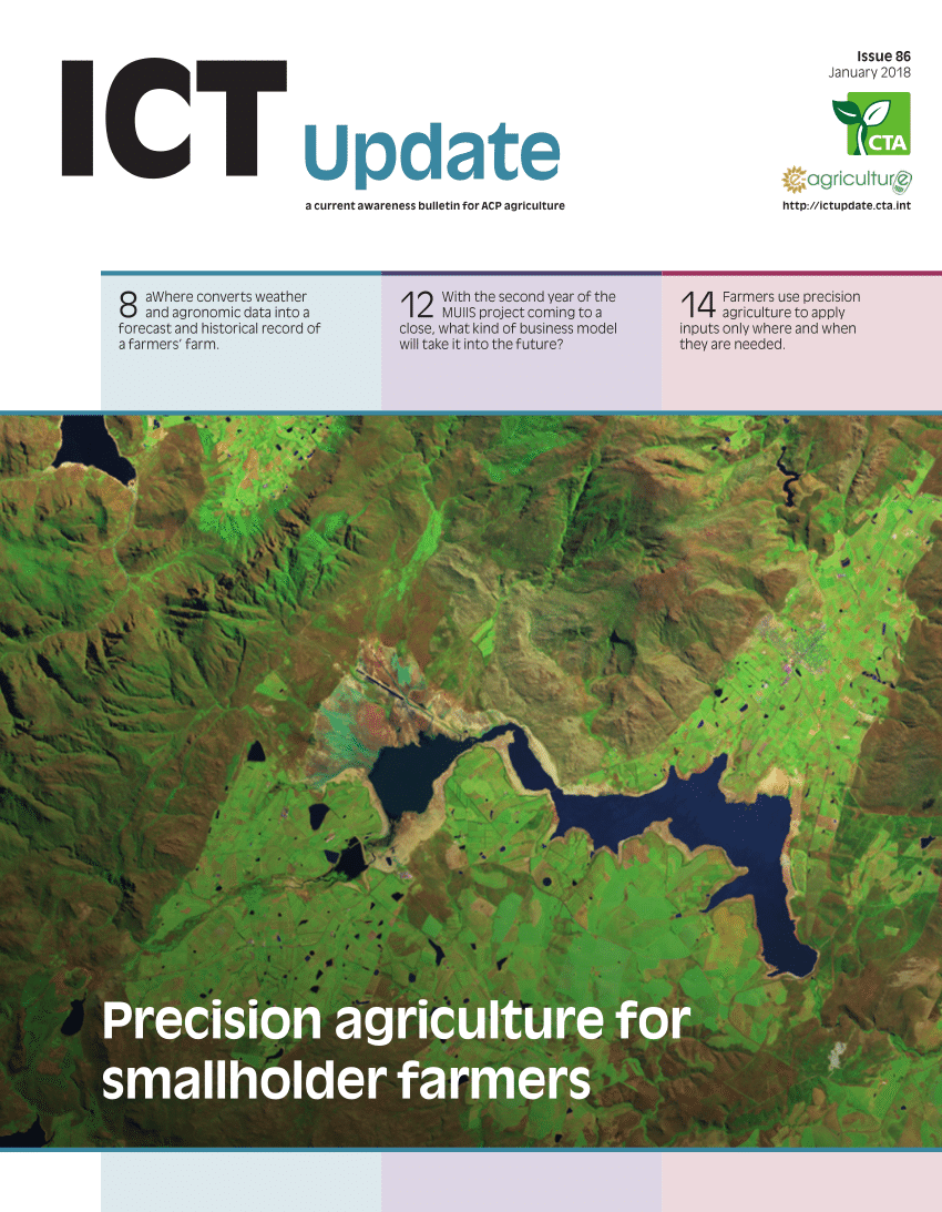
10 February – 28 February 2019. ICARDA Cairo, Egypt. Geospatial technologies is a term used to
describe the range of modern tools contributing to the geographic mapping and analysis of the Earth and human societies. Especially in the last decade, these technologies have evolved into a network of national security, scientific, and commercially operated satellites complemented by powerful desktop GIS.
High quality hardware and data is now available to new audiences such as universities, corporations, and non-governmental organizations. The fields and sectors deploying these technologies are currently growing at a rapid pace, informing decision makers on topics such as industrial engineering, biodiversity conservation, forest fire suppression, agricultural monitoring, humanitarian relief, and much more.
Overarching goal of this course was to introduce a state of the art of geoinformatics platform for pursuing research, outputs and outcome generation. Through this lecture cum practice-based training helps scientists
Source: PAEPARD FEED
by secretary
by secretary
by secretary
by secretary
by secretary
by secretary
by secretary
by secretary
by secretary
by secretary
by secretary
by secretary
by secretary
by secretary
by secretary
by secretary
by secretary
by secretary
by secretary
by secretary
by secretary
by secretary
by secretary
by secretary
by secretary
by secretary
by secretary
by secretary
by secretary
by secretary
by secretary
by secretary
by secretary
by secretary
by secretary
by secretary
by secretary
by secretary
by secretary
by secretary
by secretary
by secretary
by secretary
by secretary
by secretary
by secretary
by secretary
by secretary
by secretary
by secretary
by secretary
by secretary
by secretary
by secretary
by secretary
by secretary
by secretary
by secretary
by secretary
by secretary
by secretary
by secretary
by secretary
by secretary
by secretary
by secretary
by secretary
by secretary
by secretary
by secretary
by secretary
by secretary
by secretary
by secretary
by secretary
by secretary
by secretary
by secretary
by secretary
by secretary
by secretary
by secretary
by secretary
by secretary
by secretary
by secretary
by secretary
by secretary
by secretary
by secretary
by secretary
by secretary
by secretary
by secretary
by secretary
by secretary
by secretary
by secretary
by secretary
by secretary
by secretary
by secretary
by secretary
by secretary
by secretary
by secretary
by secretary
by secretary
by secretary
by secretary
by secretary
by secretary
by secretary
by secretary
by secretary
by secretary
by secretary
by secretary
by secretary
by secretary
by secretary
by secretary
by secretary
by secretary
by secretary
by secretary
by secretary
by secretary
by secretary
by secretary
by secretary
by secretary
by secretary
by secretary
by secretary
by secretary
by secretary
by secretary
by secretary
by secretary
by secretary
by secretary
by secretary
by secretary
by secretary
by secretary
by secretary
by secretary
by secretary
by secretary
by secretary
by secretary
by secretary
by secretary
by secretary
by secretary
by secretary
by secretary
by secretary
by secretary
by secretary
by secretary
by secretary
by secretary
by secretary
by secretary
by secretary
by secretary
by secretary
by secretary
by secretary
by secretary
by secretary
by secretary
by secretary
by secretary
by secretary
by secretary
by secretary
by secretary
by secretary
by secretary
by secretary
by secretary
by secretary
by secretary
by secretary
by secretary
by secretary
by secretary
by secretary
by secretary
by secretary
by secretary
by secretary
by secretary
by secretary
by secretary
by secretary
by secretary
by secretary
by secretary
by secretary
by secretary
by secretary
by secretary
by secretary
by secretary
by secretary
by secretary
by secretary
by secretary
by secretary
by secretary
by secretary
by secretary
by secretary
by secretary
by secretary
by secretary
by secretary
by secretary
by secretary
by secretary
by secretary
by secretary
by secretary
by secretary
by secretary
by secretary
by secretary
by secretary
by secretary
by secretary
by secretary
by secretary
by secretary
by secretary
by secretary
by secretary
by secretary
by secretary
by secretary
by secretary
by secretary
by secretary
by secretary
by secretary
by secretary
by secretary
by secretary
by secretary
by secretary
by secretary
by secretary
by secretary
by secretary
by secretary
by secretary
by secretary
by secretary
by secretary
by secretary
by secretary
by secretary
by secretary
by secretary
by secretary
by secretary
by secretary
by secretary
by secretary
by secretary
by secretary
by secretary
by secretary
by secretary
by secretary
by secretary
by secretary
by secretary
by secretary
by secretary
by secretary
by secretary
by secretary
by secretary
by secretary
by secretary
by secretary
by secretary
by secretary
by secretary
by secretary
by secretary
by secretary
by secretary
by secretary
by secretary
by secretary
by secretary
by secretary
by secretary
by secretary
by secretary
by secretary
by secretary
by secretary
by secretary
by secretary
by secretary
by secretary
by secretary
by secretary
by secretary
by secretary
by secretary
by secretary
by secretary
by secretary
by secretary
by secretary
by secretary
by secretary
by secretary
by secretary
by secretary
by secretary
by secretary
by secretary
by secretary
by secretary
by secretary
by secretary
by secretary
by secretary
by secretary
by secretary
by secretary
by secretary
by secretary
by secretary
by secretary
by secretary
by secretary
by secretary
by secretary
by secretary
by secretary
by secretary
by secretary
by secretary
by secretary
by secretary
by secretary
by secretary
by secretary
by secretary
by secretary
by secretary
by secretary
by secretary
by secretary
by secretary
by secretary
by secretary
by secretary
by secretary
by secretary
by secretary
by secretary
by secretary
by secretary
by secretary
by secretary
by secretary
by secretary
by secretary
by secretary
by secretary
by secretary
by secretary
by secretary
by secretary
by secretary
by secretary
by secretary
by secretary
by secretary
by secretary
by secretary
by secretary
by secretary
by secretary
by secretary
by secretary
by secretary
by secretary
by secretary
by secretary
by secretary
by secretary
by secretary
by secretary
by secretary
by secretary
by secretary
by secretary
by secretary
by secretary
by secretary
by secretary
by secretary
by secretary
by secretary
by secretary
by secretary
by secretary
by secretary
by secretary
by secretary
by secretary
by secretary
by secretary
by secretary
by secretary
by secretary
by secretary
by secretary
by secretary
by secretary
by secretary
by secretary
by secretary
by secretary
by secretary
by secretary
by secretary
by secretary
by secretary
by secretary
by secretary
by secretary
by secretary
by secretary
by secretary
by secretary
by secretary
by secretary
by secretary
by secretary
by secretary
by secretary
by secretary
by secretary
by secretary
by secretary
by secretary
by secretary
by secretary
by secretary
by secretary
by secretary
by secretary
by secretary
by secretary
by secretary
by secretary
by secretary
by secretary
by secretary
by secretary
by secretary
by secretary
by secretary
by secretary
by secretary
by secretary
by secretary
by secretary
by secretary
by secretary
by secretary
by secretary
by secretary
by secretary
by secretary
by secretary
by secretary
by secretary
by secretary
by secretary
by secretary
by secretary
by secretary
by secretary
by secretary
by secretary
by secretary
by secretary
by secretary
by secretary
by secretary
by secretary
by secretary
by secretary
by secretary
by secretary
by secretary
by secretary
by secretary
by secretary
by secretary
by secretary
by secretary
by secretary
by secretary
by secretary
by secretary
by secretary
by secretary
by secretary
by secretary
by secretary
by secretary
by secretary
by secretary
by secretary
by secretary
by secretary
by secretary
by secretary
by secretary
by secretary
by secretary
by secretary
by secretary
by secretary
by secretary
by secretary
by secretary
by secretary
by secretary
by secretary
by secretary
by secretary
by secretary
by secretary
by secretary
by secretary
by secretary
by secretary
by secretary
by secretary
by secretary
by secretary
by secretary
by secretary
by secretary
by secretary
by secretary
by secretary
by secretary
by secretary
by secretary
by secretary
by secretary
by secretary
by secretary
by secretary
by secretary
by secretary
by secretary
by secretary
by secretary
by secretary
by secretary
by secretary
by secretary
by secretary
by secretary
by secretary
by secretary
by secretary
by secretary
by secretary
by secretary
by secretary
by secretary
by secretary
by secretary
by secretary
by secretary
by secretary
by secretary
by secretary
by secretary
by secretary
by secretary
by secretary
by secretary
by secretary
by secretary
by secretary
by secretary
by secretary
by secretary
by secretary
by secretary
by secretary
by secretary
by secretary
by secretary
by secretary
by secretary
by secretary
by secretary
by secretary
by secretary
by secretary
by secretary
by secretary
by secretary
by secretary
by secretary
by secretary
by secretary
by secretary
by secretary
by secretary
by secretary
by secretary
by secretary
by secretary
by secretary
by secretary
by secretary
by secretary
by secretary
by secretary
by secretary
by secretary
by secretary
by secretary
by secretary
by secretary
by secretary
by secretary
by secretary
by secretary
by secretary
by secretary
by secretary
by secretary
by secretary
by secretary
by secretary
by secretary
by secretary
by secretary
by secretary
by secretary
by secretary
by secretary
by secretary
by secretary
by secretary
by secretary
by secretary
by secretary
by secretary
by secretary
by secretary
by secretary
by secretary
by secretary
by secretary
by secretary
by secretary
by secretary
by admin
by admin
by admin
by admin
by admin
by admin
by admin
by admin
by admin